Stop searching the same ground twice
Upgrade GeoDetectit to unlock a more structured field workflow with better map support, coverage tracking and export tools. The result is better coverage, better analysis and less wasted time in the field.
The real problem
Many detecting sessions become unsystematic. You spend hours in the field, get interesting signals, but later you no longer remember exactly where you walked, where the productive areas were, or what remains to search.
- The same ground gets searched again.
- Promising zones are lost between sessions.
- Documentation ends up split across photos, notes and memory.
- The next session starts from guesswork instead of data.
With Field features
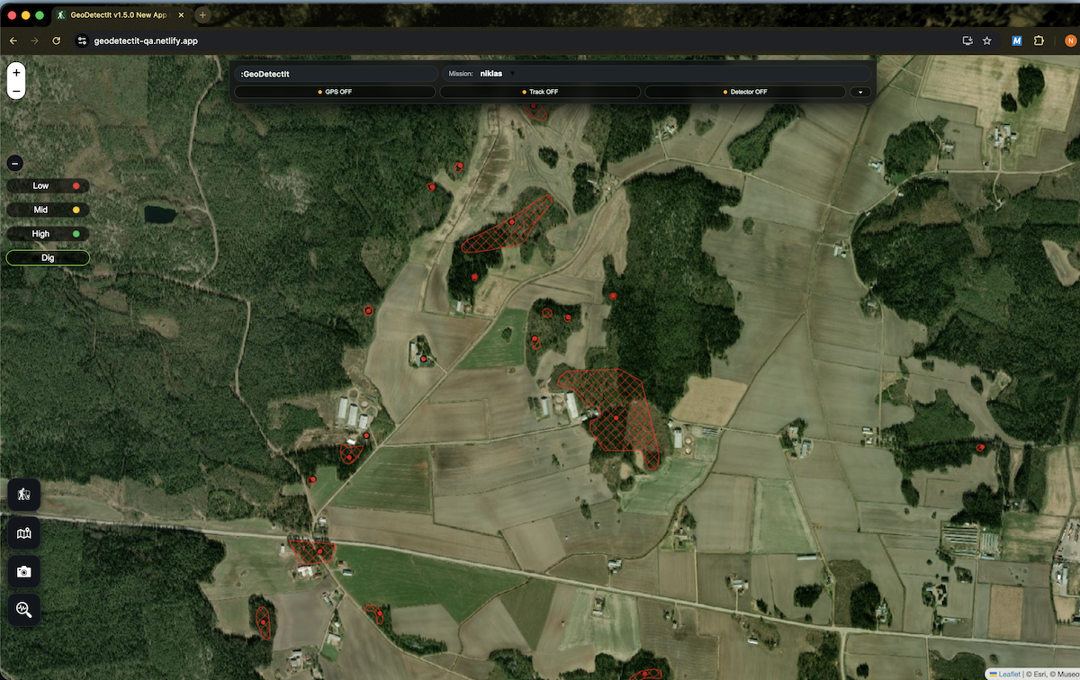
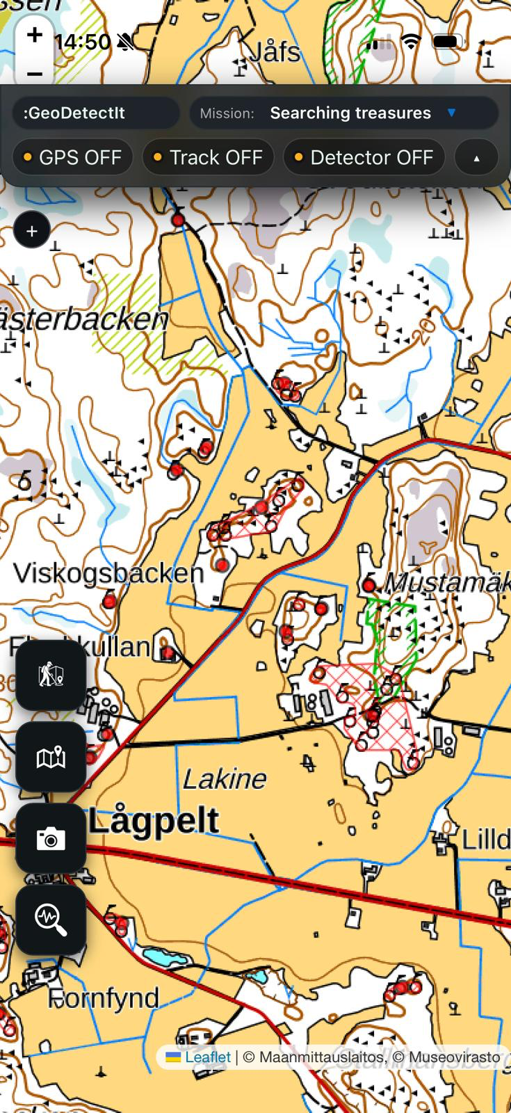
GeoDetectit Field turns detecting into a more structured process. You can see what has been done, what remains, and where the useful results actually came from.
- See exactly where you have already walked.
- Identify gaps in coverage.
- Document finds with geotagged photos and notes.
- Export complete missions for analysis, archive or sharing.
- Build a real field archive over time.
Advanced map layers
Access stronger basemaps, orthophotos, archaeology, protected heritage areas and regional overlays. The platform is already built to support several useful map service types.
Unlimited missions
Organise work in missions with areas, tracks, signals, photos and stats. Ideal when you return to the same site over several days, weeks or seasons.
Export & backup
Keep full control of your data with open formats and complete ZIP backups. Use in GIS, store locally or share with others.
What you actually get
- Better planning: choose search areas using stronger map support.
- Less overlap: see where you have already searched.
- More structure: keep tracks, signals, photos and notes together in one mission.
- Better decisions: know where to continue next time.
- Safer documentation: export and archive your field data.
Built on the right principles
- Offline-first: the app should work in the field, not only when connected.
- Local-first: data stays on your own device.
- No forced cloud: no mandatory cloud-first workflow.
- You own your data: export in open formats.
- Capability over lock-in: you pay for tools, not for data captivity.
Manage subscription first
If you already have a subscription, start here for billing, account and access-related questions.
- Update payment details
- Check subscription status
- Log in again after purchase
- Manage your account and license access
Common subscription questions
Subscription not activated?
Make sure you are logged in with the same account you used for purchase. If access still does not activate, log out and log in again.
Email not verified?
Check your inbox and spam folder for the verification email. Subscription features may stay locked until your email is verified.
Changed phone or tablet?
A subscription is intended for up to 3 devices per user under fair use.
Billing issue?
Use the manage subscription button above first. That is the fastest route for payment and renewal issues.
Still need help?
If something is not working with your subscription, access or activation, contact support and describe what happened.
Include your device, what happened, and what you already tried.
Ideas for Field?
GeoDetectit is built by a detectorist, for detectorists. If you have ideas for better field workflows, field features or map support, I’d really like to hear them.
Field tools
Search coverage
Gain better control over which parts of a site have already been searched and which are still open. Especially valuable on larger fields, repeat sessions and wooded areas.
Photo & find documentation
Document finds directly in the field with geotagged images, category and comments. This keeps important context from being lost.
Detector profiles
Save and reuse setups for different detectors, signal preferences or field conditions. Useful when you want more consistency across sessions and devices.
ZIP mission backup
Export a complete mission with geodata, metadata and photos in one coherent archive format.
Free vs Field
| Feature | Free | Field |
|---|---|---|
| Basic detecting workflow | ✓ | ✓ |
| Missions | 1 | Unlimited |
| GPS tracking | ✓ | ✓ |
| Signal logging | ✓ | ✓ |
| Photo documentation | 5 | Unlimited |
| Import missions | — | ✓ |
| Export missions | — | ✓ |
| ZIP backup | — | ✓ |
| Detector profiles | — | ✓ |
| Advanced map layers | — | ✓ |
| Offline tile cache | — | ✓ |
| Devices per license | 1 | Up to 3 |
GeoDetectit Field focuses on features that create real field value: more missions, better map support, backup, export and a more structured workflow.
Activation
After purchase, log in with your account and activate your subscription inside the app.
- Upgrade through checkout.
- Verify your email if needed.
- Log in to the app.
- Open the subscription area.
- Your subscription access should appear automatically.
Privacy & ownership
GeoDetectit is built on one simple principle: your data is yours.
- No forced cloud storage.
- Data stays on your device by default.
- Export in open formats: GeoJSON, GPX, KML and ZIP.
- Cloud may come later as an option — never a requirement.
Privacy Policy
Ready to upgrade?
Upgrade your subscription and build a more structured, portable and reliable field workflow.
FAQ
Is an account required for a subscription?
Yes. An account is required for a subscription. It is used to secure your subscription, while your field data remains stored locally on your own device.
Can I use the app offline?
Yes. GeoDetectit is built offline-first. Some maps may require available or cached map data.
What if I change device?
The license model is intended for up to 3 devices per user within fair use.
What is the main value of Field?
It turns field sessions from ad hoc work into a more structured process with stronger traceability, backup and planning.