Metal Detecting Map Germany – Historic Maps & Protected Areas
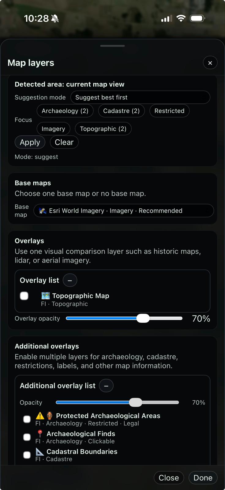
Looking for the best map layers for metal detecting in Germany? GeoDetectit helps you combine historic maps, archaeological protection zones, known archaeological sites, LiDAR terrain and topographic layers in one workflow.
Why this matters
Germany has valuable public map data, but it is often split across separate services. GeoDetectit brings relevant detecting layers together in one place.

Best map layers for metal detecting in Germany
The best workflow is usually not one map, but a combination of layers that answer different questions: where historic activity happened, where protected archaeology exists, what the terrain reveals, and how to orient yourself in the field.
1. Historic maps
Historic maps are one of the most useful sources when you want to identify lost roads, earlier settlement patterns, field divisions and older land use.
- compare older landscapes with modern aerial imagery
- spot vanished paths, structures and settlement traces
- find search areas with stronger historical context
2. Protected archaeological areas
Before searching, you need to understand whether an area is legally sensitive, protected or restricted. These layers are critical for responsible fieldwork.
- see archaeological protection zones directly on the map
- avoid planning in restricted areas
- understand heritage-sensitive regions before going out
3. Archaeological sites
Known archaeological sites and cultural heritage layers provide important context. They help you understand the landscape, even when detecting is not appropriate in or near those areas.
- known sites add historical context to the area
- useful for planning and interpretation
- helps separate promising background areas from sensitive ones
4. LiDAR and terrain
Hillshade and terrain models can reveal subtle landforms, earthworks, hollow ways and structure traces that are difficult to notice in ordinary aerial imagery.
- see terrain changes more clearly
- useful in forest and uneven ground
- supports better interpretation of old landscapes
Examples of useful Germany layers in GeoDetectit
GeoDetectit can combine regional and official layers that matter for detectorists and field researchers.
Schleswig-Holstein protection zones
Official archaeological protection zone layers help identify restricted or legally protected areas before planning a search.
Schleswig-Holstein archaeological sites
Cultural monument layers add archaeological context and help you understand where heritage sensitivity is already known.
Saxony historic maps
Historic map overlays such as Meilenblatt are especially valuable when comparing older field structures with the modern landscape.
Saxony LiDAR terrain
Two different LiDAR-based layers are available depending on use case:
- LiDAR intensity – shows surface reflection and ground patterns
- DGM hillshade – highlights terrain shape and elevation
These layers complement each other and are often used together when analyzing subtle landscape features.
About coverage and map layers in Germany
Germany is a strong example of what is possible with public map data — but also a good example of why map coverage is not uniform.
Most map layers in GeoDetectit come from regional authorities. Each state (Bundesland) publishes data differently, using different WMS, WMTS or ArcGIS services, with varying availability and technical requirements.
Because of this, coverage is built step by step — starting with regions where useful, stable and relevant layers are available.
Why Saxony is used as an example
Saxony is currently one of the regions used to demonstrate what is possible when combining historic maps, LiDAR terrain and archaeology layers in one workflow.
- historic maps (Meilenblatt)
- LiDAR intensity and terrain (DGM hillshade)
- clear regional WMS services
This makes it a good reference area for how layers can be combined for real field planning.
Not every region is included (yet)
It is not practical to integrate every country and region upfront. Each layer requires evaluation, testing and integration.
- different data formats and services
- varying access rules and restrictions
- technical differences between providers
The focus is therefore on areas where the layers actually create value in the field.
Community-driven expansion
If you know useful map layers in your region — from other map portals or GIS services — you can help expand GeoDetectit.
- share WMS / WMTS / ArcGIS links
- suggest useful archaeology, lidar or historic layers
- help identify what actually matters in the field
GeoDetectit is built around real use, not theoretical coverage. New regions are added where there is real demand and useful data that improves field planning.
Technical note
Some layers are accessed directly from public services, while others require additional handling to work reliably in the browser.
In GeoDetectit, this is handled transparently — so you can focus on comparing layers and making decisions, instead of dealing with map service limitations.
Recommended workflow in Germany
A practical workflow is to start broad and then narrow down:
- start with topographic or satellite basemap
- add historic map overlay to compare old and modern landscape
- turn on archaeological protection zones
- check archaeological site layers for context
- use LiDAR or hillshade where terrain interpretation matters
- track your route and document finds in the field
Best combination
Historic maps + protected areas + LiDAR is often the strongest combination for pre-field analysis.
What makes a map layer useful for detecting?
- historical relevance and context
- awareness of legal and protected areas
- terrain interpretation and landscape reading
- practical usability in the field
Why not just use separate websites?
Many detectorists still work with multiple browser tabs, screenshots and memory. That often leads to slower planning and weaker documentation.
- historic maps in one place
- protected zones in another
- find notes somewhere else
- GPS track stored separately
Why GeoDetectit is better in the field
GeoDetectit turns map reading into a working field workflow.
- plan search areas before going out
- track your route with GPS
- document finds with photos and notes
- keep your work portable and exportable
- work offline when needed
Frequently asked questions
Can I use historic maps in Germany for detecting research?
Yes, historic maps are excellent for research and planning. They help you understand how the landscape looked before modern changes.
Why are protected areas important?
Because some archaeological zones are legally protected or sensitive. You should always understand the restrictions before planning field activity.
Is LiDAR useful for metal detecting?
Yes. LiDAR and hillshade can reveal terrain details and old landscape structures that are not obvious in aerial imagery.
Can I use GeoDetectit offline in the field?
Yes. GeoDetectit is built with an offline-first approach for serious field use.
Open the Germany map
Explore historic maps, archaeological protection zones, archaeological sites and terrain layers in one detecting workflow.
Plan better before entering the field
Use map layers, GPS tracking and field documentation in one place instead of switching between multiple services.